GEOGRAPHY & LANDSCAPES
Cactus, Deserts, Mountains, Rainforests & Gorgeous Beaches – That´s México!
The diverse landscape of Mexico is mainly due to the country’s favorable geographic location. From deep gorges in the Copper Canyon over wide cactus deserts in Baja California to snow covered volcanoes in Central Mexico and beautiful waterfalls in the tropical rainforest in the Husteca Potosina and Chiapas – experience all of the scenic diversity on a tour of Mexico.
 Geographical Location:
Mexico is located in between North and Central America and borders the United States to the north and Guatemala and Belize in the south. The northern and central parts of Mexico belong to North America and bordering the southern state of Chiapas is where Central America begins.
From north to south and east to west you can find a wide variety of landscapes, climates and flora and fauna. The climate is also strongly influenced by the Pacific Ocean in the west, the Gulf of Mexico in the east and the Caribbean Sea in the southeast.
Area & Extent:
With an area of almost 2 million km2, Mexico is 5 times as large as Germany and with about 113 million inhabitants in 11th place in terms of population. Around 25 million of them live in the capital of Mexico City and surroundings. The next largest cities are Ecatepec (Méxcio), Guadalajara (Jalisco), Ciudad Juarez (Chihuahua) and Puebla de Zaragoza (Puebla). The country is divided into 31 states and 1 federal district. You can find a detailed description of the individual states and their attractions here.
| Largest City: Mexico City (25 Mio.) |
| Largest State: Chihuahua (250.000km2) |
| Longest River: Rio Bravo del Norte (3.100km) |
| Largest Lake: Chapala-Lake (1.120km2) |
| Highest Mountain: Volcanoe Pico de Orizaba (5636m) |
| Lowest Point: Mexicali (-10m) |
Geographical Zones in Mexico from North to South:
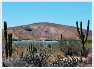 North Pacific
Desert, Cacti & Oasis
These include the Baja California Peninsula and the plains of Sonora and Sinaloa. Baja California is the longest peninsula in the world. It runs along the northwest coast and is separated from the Mexican mainland by the Gulf of California. The entire area is characterized by a dry climate, only in Baja California Sur (the southern part of the peninsula) are fertile areas which is why this region has some agriculture development.
There are particularly beautiful beaches and numerous hidden lagoons along the Gulf Coast, while the beach sections on the Pacific coast are repeatedly interrupted by steep cliffs. Baja California is also crossed by a mountain range, in contrast to Sonora and Sinaloa, where flat, wide valleys predominate.–
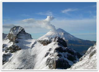 Highlands Central México
Beautiful Mountain Ranges & Snow Covered Volcanoes
Since most of the country is made up of highlands, there are several 5000m+ mountains in the southern region of the Sierra Madre. The mountain ranges of the Sierra Madre Occidental and Sierra Madre Oriental run from north to south. The Sierra Gorda extends further south in the state of Querétaro and the Sierra Madre del Sur in Oaxaca.
Sierra Volcanico rises further south near Mexico City, where the country’s famous volcanoes are located.
In addition to the twin volcanoes Iztaccihuatl and Popocatepetl which erupted for the last time in 2012, there is also the volcano Pico de Orizaba, the summit of which is Mexico’s highest point at 5,600 meters, and La Malinche with 4500 meters. The mighty mountain ranges stretch far south to the highlands of the Chiapas region, where the lush forested tropical zone begins.–
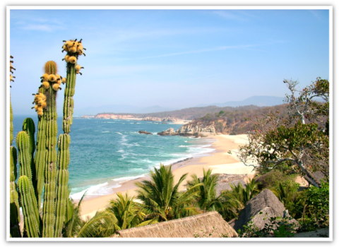 Coastal Plains on the Pacific
Palm-lined Beaches and Surf Spots
From Tepic in the state of Nayarit, the climate and vegetation on the Pacific Coast become more tropical as you move south. There are many popular seaside resorts along the coast, from Sayulita, Puerto Vallarta, Zihuatanejo and Ixtapa to Acapulco. The beaches on the coast of Oaxaca (Puerto Escondido, Mazunte, Salina Cruz) are particularly popular with surfers due to the favorable winds. They also invite you to relax with their isolated, turquoise bays.–
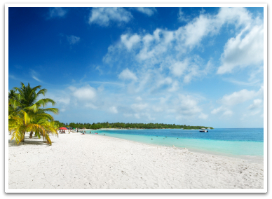 Chiapas, Yucatan and Caribbean Coast
Dense Jungle & Pristine Beaches
Chiapas and the Yucatan are characterized by tropical jungles and you can find an incredible variety of plant species, especially in the Calakmul Biosphere Reserve in Campeche and the Montes Azules National Park in Chiapas. The Yucatan Peninsula is known for cenotes which are underground caves where you can swim and scuba dive. On the Caribbean Coast of Mexico you will find the most beautiful beaches in the country with white sandy beaches, azure blue water and lush jungle vegetation. Along the coast are the country’s most popular vacation spots, Cancun, Playa del Carmen and Tulum. Further south near the border with Belize, you will find quieter, natural beaches and also the well-known biosphere reserve Sian-Ka’an, which has been a UNESCO World Heritage Site since 1987. In the Caribbean Sea you will also find some pictureque islands. Particularly popular are Isla Holbox, Isla Mujeres and Cozumel which are easily accessible from the mainland.
Geographical features
Mexico´s Volcanoes
The most famous “twin volcanoes” Popocatétpetl and Iztaccihuatl are located approx. 70 km southeast of Mexico City in national parks of the same name. The snow-capped peaks can be seen from Mexico City and Puebla.
The name Popocatepetl comes from the Aztecs and means “heavily smoking mountain”. According to legend, Popocatepetl was a mercenary who immortalized himself in the king’s daughter Iztaccihuatl. The king promised to marry the two if Popocateptl would successfully return home from the war, but he was secretly planning to marry his daughter to someone else. The war lasted a very long time and so King Iztaccihuatl finally told her that her loved one had died, whereupon she committed suicide. When Popocatepetl returned and found his lover dead, he took her to the highest mountain. The gods took pity on the bereaved and covered them with a blanket of snow. Since then, Iztaccihuatl (its shape resembles that of a sleeping woman) has been sleeping in the arms of Popocatepetl, who watches over her with his smoking torch.
The Cenotes of the Yucatan Peninsula
The cenotes found in Mexico on the Yucatan Peninsula are a unique geographical formation found in the region. The word “cenote” comes from the Mayan language Dzonot and means “holy well”. For the Mayans, the cenotes were sacred places because they were an important source of water and were therefore also considered the dwelling place of the rain god Chac. In addition, the cenotes were viewed as the gateway to the underworld of Xibalba and were often used as places of sacrifice.
Exploration of the cenotes in Mexico did not begin until around 1980 and over 30 cave systems have been discovered since then. Cenotes occur when infiltrating, carbon dioxide-containing rainwater penetrates the earth and the carbon dioxide dissolves the limestone over millions of years. This is how the extensive interconnected cave systems were created. There are open and closed cenotes. The open cenotes are huge water holes that occur when a cave roof collapses and the closed cenotes are covered caves with stalactites and stalagmites. The Yucatan cenotes are thought to be the world’s largest underwater cave system, 1085 km long, although only a portion of it has been explored to date.
Diving in the cenotes became more popular with increasing exploration of the caves, both by locals and tourists. A scuba diving license is required for these tours. The most beautiful cenote dive sites include the cenotes Dos Ojos and Aktun Chen near Tulum. Even if you are not enthusiastic about diving, you should definitely take a trip to a cenote where you can swim or snorkel in the natural beauty of the cenote.
The Copper Canyon
The Copper Canyon (sp. Cañon del Cobre) is a mountain formation in the Sierra Madre Occidental in the northwest of the country. The canyon was formed by a formerly strong river course and got its name from the red coloring of the rock. The gorge is about 50 km long and in some places up to 1800m deep, making it one of the largest canyons in North America and almost four times the size of the Grand Canyon. The area is partially populated by the Tarahumara Indians. The “El Chepe” railway, which runs along the canyon from Chihuahua to Los Mochis, is particularly well known.
Our Mexico Partners


Our Team